Urban greenhouse gas and air quality monitoring
Our research tackles two of today’s most urgent challenges: climate change and air pollution. My group and I have not only developed new types of sensors, but also carried out research on interdisciplinary issues, including the development of novel mathematical methods and atmospheric models. We have initiated two pilot projects, unique in the world, to quantify urban greenhouse gas emissions and air quality.

Focus Group Environmental Sensing and Modeling
Prof. Jia Chen (TUM), Alumna Rudolf Mößbauer Tenure Track Assistant Professor |
Dr. Shrutilipi Bhattacharjee (TUM), Postdoctoral Researcher | Florian Dietrich, Xinxu Zhao (TUM), Doctoral Candidates
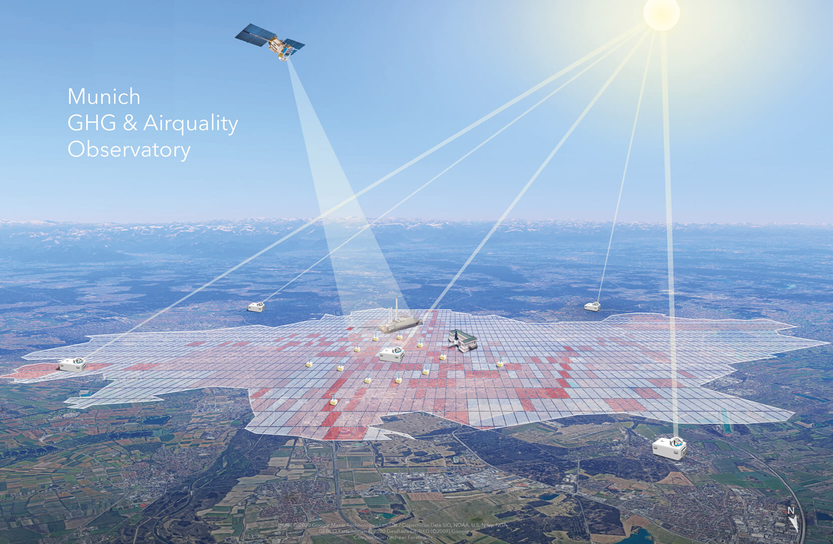
Worldwide unique greenhouse gas network
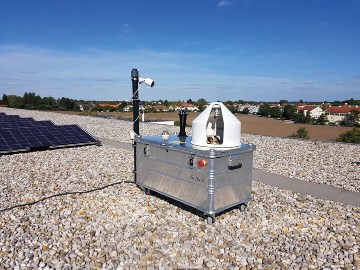
In 2019, my group established a fully automated long-term sensor network in Munich to measure CO2, CH4, and CO [1], which is based on the differential column measurement (DCM) principle that I developed [2]. The network consists of five solar-tracking Fourier transform infrared (FTIR) spectrometers integrated into our patented automated enclosure systems [3]. The configuration of the network is depicted in Figure 1. Four stations are located on the outskirts of the city to capture the inflow / outflow column concentrations in arbitrary wind conditions. One inner-city station serves as a permanent downwind site for half of the city.
The fully autonomous DCM sensor network in Munich is the first of its kind and unique worldwide. With this network, my group monitors the long-term greenhouse gas trends in Munich and traces unknown emission sources with unprecedented accuracy [4]. We are currently developing an extension to the sensor system that will measure NO2 and O3 in the future. Our automated enclosure systems are deployed not only in Munich, but also in places at extreme latitudes, and with difficult access and demanding climatic conditions, e.g., in Finland, north of the polar circle, and in Uganda at the equator [5]. The system in Uganda provides the first ground-based observations of greenhouse gas columns over East Africa, thus enabling the study of wetland emissions, which account for a third of global methane growth. The modeling approaches we developed have also been used to assess emissions in other cities in the world [6].
Figure 1
A new concept for assessing urban air quality
To assess the human exposure to air pollutants and define the best mitigation strategies for NOx and PM, we need to gain a better understanding of their spatial distributions at the neighborhood level. The very limited spatial coverage of the present governmental stations, however, prevents us from achieving this goal. Further, the governmental stations do not necessarily capture the street level pollutant exposure, as their inlets are positioned 4 m above the ground. Our in situ mobile measurements reveal a discrepancy of 48 % between the governmental stations and the spatially averaged street-level data in their vicinity [7]. My group is currently setting up an autonomous NOx, PM, CO and O3 network in Munich, consisting of 50 stand-alone sensor systems. My group developed these systems, which are characterized by very low power consumption, an IoT (Internet of Things) communication interface, and a compact and lightweight design. The sensor network will provide air quality measurement data with a high spatial (every 200 m) and temporal (1 min) resolution. To ensure data quality, these sensors will be automatically calibrated twice a week, using high-precision mobile reference sensors. The calibration process will be supported by machine learning algorithms to compensate for cross-sensitivity, drift, and aging effects.
New ERC Proof of Concept grant awarded to Michael Bronstein in 2020
Michael Bronstein was awarded the ERC Proof of Concept grant Hyperfoods, to explore the commercial application of graph-based deep learning methods for discovering drug-like molecules in food ingredients. The project, based on previous research of Michael Bronstein on drug repositioning, took a tasty twist through collaboration with the renowned Italian chef Bruno Barbieri, who prepared a series of recipes based on ingredients the team identified. Following an ERC Starting Grant, an ERC Consolidator Grant, and two ERC Proof of Concept Grants, Hyperfoods is Michael Bronstein's fifth grant from the European Research Council.
Application of satellite data
I am a member of the NASA OCO satellite science team and use this one-of-a-kind dataset of global CO2 concentration and SIF (solar induced fluorescence) to study important questions relating to CO2 emissions. For example, we were able to reveal that CO2 emissions from the Nile Delta are about 1 % of the global anthropogenic emissions, which is significantly more than previously assumed [8].
Apart from identifying greenhouse gas sources worldwide, we are also interested in how climate change affects the behavior of carbon sinks [9]. We also employ the data of the European Sentinel-2 satellite in our studies: With the help of a neural network, this data was used to quantify the distribution of the invasive eucalyptus population in Portugal [10].
Moreover, we pursue innovative approaches to data fusion, which are of vital importance in analyzing satellite data. My group developed the Semantic Kriging method, which creates new possibilities for spatial interpolation of measurement data [11].
Figure 2
[1]
Dietrich et al. (2021).
[2]
Chen et al. (2016).
[3]
Heinle, L. & Chen, J. Automated Enclosure and Protection System for Compact Solar-Tracking Spectrometers. Atmos. Meas. Tech. 11, 2173–2185 (2018), https://doi.org/10.5194/amt-11-2173-2018.
[4]
Chen et al. (2020); Toja-Silva, F., Chen, J., Hachinger, S., Hase, F. CFD simulation of CO2 dispersion from urban thermal power plant: Analysis of turbulent Schmidt number and comparison with Gaussian plume model and measurements. Journal of Wind Engineering and Industrial Aerodynamics 169, 177–193 (2017). https://doi.org/10.1016/j.jweia.2017.07.015.
[5]
Dietrich et al. (2021).
[6]
Jones, T. S., Franklin, J. E., Chen, J., Dietrich, F., Hajny, K. D., Paetzold, J. C., Wenzel, A., Gately, C., Gottlieb, E., Parker, H., Dubey, M., Hase, F., Shepson, P. B., Mielke, L. H. & Wofsy, S. C. Assessing urban methane emissions using column-observing portable Fourier transform infrared (FTIR) spectrometers and a novel Bayesian inversion framework. Atmos. Chem. Phys. 21, 13131–13147 (2021), https://doi.org/10.5194/acp-21-13131-2021; Zhao, X., Marshall, J., Hachinger, S., Gerbig, C., Frey, M., Hase, F. & Chen, J. Analysis of total column CO2 and CH4 measurements in Berlin with WRF-GHG. Atmos. Chem. Phys. 19, 11279–11302 (2019), https://doi.org/10.5194/acp-19-11279-2019.
[7]
Zhu, Y., Chen, J., Bi, X., Kuhlmann, G., Chan, K. L., Dietrich, F., Brunner, D., Ye, S. & Wenig, M. Spatial and temporal representativeness of point measurements for nitrogen dioxide pollution levels in cities. Atmos. Chem. Phys. 20, 13241–13251 (2020), https://doi.org/10.5194/acp-20-13241-2020.
[8]
Shekhar, A., Chen, J., Bhattacharjee, S., Buras, A., Castro, A.O., Zang, C.S., Rammig, A. Capturing the Impact of the 2018 European Drought and Heat across Different Vegetation Types Using OCO-2 Solar-Induced Fluorescence. Remote Sensing 12, 3249 (2020a), https://doi.org/10.3390/rs12193249.
[9]
Shekar, A. et al. (2020b); Castro, A. O., Chen, J., Zang, C. S., Shekhar, A., Jimenez, J. C., Bhattacharjee, S., Kindu, M., Morales, V. H., Rammig, A. OCO-2 Solar-Induced Chlorophyll Fluorescence Variability across Ecoregions of the Amazon Basin and the Extreme Drought Effects of El Niño (2015–2016). Remote Sensing 12, 1202 (2020), https://doi.org/10.3390/rs12071202.
[10]
Forstmaier, A., Shekhar, A. & Chen, J. Mapping of Eucalyptus in Natura 2000 Areas Using Sentinel 2 Imagery and Artificial Neural Networks. Remote Sensing 12, 2176 (2020), https://doi.org/10.3390/rs12142176.
[11]
Bhattarcharjee, S. & Chen, J. (2020).
Selected publications
- Chen, J., Viatte, C., Hedelius, J. K., Jones, T., Franklin, J. E., Parker, H., Gottlieb, E. W., Wennberg, P. O., Dubey, M. K., and Wofsy, S. C. Differential column measurements using compact solar-tracking spectrometers. Atmos. Chem. Phys. 16, 8479–8498 (2016), https://doi.org/10.5194/acp-16-8479-2016.
- Chen, J., Dietrich, F., Maazallahi, H., Forstmaier, A., Winkler, D., Hofmann, M. E. G., Denier van der Gon, H., and R.ckmann, T. Methane emissions from the Munich Oktoberfest. Atmos. Chem. Phys. 20, 3683–3696 (2020), https://doi.org/10.5194/acp-20-3683-2020.
- Bhattacharjee, S. & Chen, J. Prediction of Satellite-Based Column CO₂ Concentration by Combining Emission Inventory and LULC Information. IEEE Transactions on Geoscience and Remote Sensing 58, 8285–8300 (2020), https://doi.org/10.1109/TGRS.2020.2985047.
- Dietrich, F., Chen, J., Voggenreiter, B., Aigner, P., Nachtigall, N., and Reger, B. MUCCnet: Munich Urban Carbon Column network. Atmos. Meas. Tech. 14, 1111–1126 (2021), doi.org/10.5194/amt-14-1111-2021.
- Shekhar, A., Chen, J., Paetzold, J. C., Dietrich, F., Zhao, X., Bhattacharjee, S., Ruisinger, V., Wofsy, S. C. Anthropogenic CO2 emissions assessment of Nile Delta using XCO2 and SIF data from OCO-2 satellite. Environ. Res. Lett. 15, 095010 (2020b), https://doi.org/10.1088/1748-9326/ab9cfe.
Full list of publications